


Precinct N24, Rapides Parish, Louisiana
About
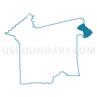
Outline

Summary
| Unique Area Identifier | 590332 |
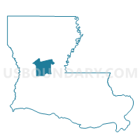
| Name | Precinct N24 |
| County | Rapides Parish |
| State | Louisiana |
| Area (square miles) | 37.36 |
| Land Area (square miles) | 36.17 |
| Water Area (square miles) | 1.19 |
| % of Land Area | 96.82 |
| % of Water Area | 3.18 |
| Latitude of the Internal Point | 31.36167410 |
| Longtitude of the Internal Point | -92.15387780 |
Maps

Graphs
Select a template below for downloading or customizing gragh for Precinct N24, Rapides Parish, Louisiana


Neighbors
Neighoring Voting District (by Name) Neighboring Voting District on the Map
- Precinct 1-2, Avoyelles Parish, LA
- Precinct 9-5, La Salle Parish, LA
- Precinct N23, Rapides Parish, LA
- Precinct N25, Rapides Parish, LA
Top 10 Neighboring County Subdivision (by Population) Neighboring County Subdivision on the Map
- District C, Rapides Parish, LA (17,587)
- District 1, Avoyelles Parish, LA (4,886)
- District 9, La Salle Parish, LA (1,387)
Top 10 Neighboring Place (by Population) Neighboring Place on the Map
Top 10 Neighboring Unified School District (by Population) Neighboring Unified School District on the Map
- Rapides Parish School District, LA (131,613)
- Avoyelles Parish School District, LA (42,073)
- La Salle Parish School District, LA (14,890)
Top 10 Neighboring State Legislative District Lower Chamber (by Population) Neighboring State Legislative District Lower Chamber on the Map
- State House District 27, LA (48,069)
- State House District 22, LA (46,175)
- State House District 28, LA (42,073)
Top 10 Neighboring State Legislative District Upper Chamber (by Population) Neighboring State Legislative District Upper Chamber on the Map
Top 10 Neighboring 111th Congressional District (by Population) Neighboring 111th Congressional District on the Map
Top 10 Neighboring Census Tract (by Population) Neighboring Census Tract on the Map
- Census Tract 101, Rapides Parish, LA (9,266)
- Census Tract 9703, La Salle Parish, LA (4,352)
- Census Tract 302, Avoyelles Parish, LA (2,735)